Mission: Phoenix College ASCENDAPRS KA7NSR-6 · ANSR ASCENDFocus: design · build · fly · analyze
NASA ASCEND
Phoenix College high-altitude balloon mission control
Phoenix College · Arizona Space Grant / ANSR mission model

Near-space payload mission control

A mission-control website for the Phoenix College ASCEND team. The payload assembly video stays as the fading aerospace background. The foreground is the Arizona flight visualization, full route context, payload systems, source-labeled data, mission video previews, gallery, FAQ, and student ownership path.

101,260 ftFall 2025 Balloon 2 result
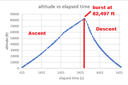
82,496.996 ftSpring APRS peak marker
83,661.518 ftaligned sensor altitude max
524 CPMradiation count-rate max
CesiumJS / APRS playback

Arizona satellite terrain under the 3D flight path

Cesium satellite imagery sits under the 3D trajectory. The altitude wall rises from the Arizona ground path, the payload marker flies the route, the launch / peak / landing labels stay visible, and the full 2D route map sits directly underneath the 3D scene.

Operator control

Scrub the timeline or let the payload fly. The readout updates from the Spring 2026 APRS JSON track while the map below gives geographic context.

APRS sourceANSR sourceLocal JSON playback
TimeT+00:00
PhaseLaunch
Altitude-- ft
Lat / Lon--
Speed-- mph
Vertical rate-- ft/s
Peak--
Duration--
Track distance--
Max speed--
CallsignKA7NSR
SourceSpring 2026 APRS

Altitude profile

Ground speed

Payload systems

Vehicle, power, software, sensors, and media

Mechanical body

  • Composite payload body with camera geometry, sensor apertures, fastener access, battery retention, and recovery access treated as review items.
  • The assembly video stays in the background because the hardware build is part of the mission identity.

Electrical stack

  • Central power plan for Arduino, science sensors, SD logging, and camera systems.
  • Review items: voltage, switches, connector retention, cold behavior, card access, and launch-day final state.

Science channels

  • Pressure, temperature, humidity, IMU, UV-A/B/C, beta/gamma count rate, CO2, and particulate channels.
  • Public numbers remain source-labeled and unit-labeled.
Data discipline

No mixed units, no unlabeled metrics

APRS route source

Used for public position tracking, route context, elapsed flight behavior, launch, peak, descent, and recovery geography.

Workbook source

Used for aligned sensor values, count-rate conversion, CO2 maxima, temperature, humidity, and particulate peaks.

Publication rule

Each public metric states the source path and unit. APRS altitude and aligned sensor altitude are not silently merged.

Mission video wall

Launch, peak-event, landing, and assembly media

Lift-off / launch slot

Uses the uploaded mission-media preview now. Full-resolution path remains videos/LIFTOFF.mp4.

Peak-event / GoPro slot

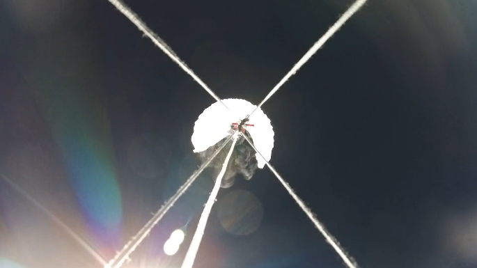
Uses the uploaded mission-media preview now. Full-resolution path remains videos/BURST.mp4.

Landing / recovery slot

Uses the uploaded mission-media preview now. Full-resolution path remains videos/LANDING.mp4.

Join the next readiness cycle

Choose a subsystem and own evidence

The next iteration needs named owners for mechanical, electrical, software, science, media, route playback, recovery, gallery, and FAQ. Every subsystem gets a checklist, evidence, source labels, and a page section.