Launch and departure
8.82 seconds. The camera clears the release team as the payload leaves the ground.

The Spring 2026 archive brings together the team's authored flight figures, atmospheric research presentation, radiation profile and onboard footage. The original figures—not fitted substitute curves— lead the science record.
Explore the team's authored trajectory and altitude profile, then read the acquired-data research presentation. These are published figures, not a live tracker or a synchronized telemetry replay. Numerical acquisition records and coordinate files remain private.
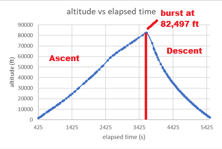
The team reports an 82,497-ft flight maximum, an external-temperature minimum of −66.5 °C and a high-altitude CO₂ peak of 939 ppm at 77,483 ft. These values belong to the supplied Spring 2026 report, not the older fitted-altitude summary.
The presentation preserves instrument behavior and the team's annotations. Interpretation notes separate observations, source-label conflicts and proposed follow-up studies.
Explore the Spring 2026 research figures →Watch the team-supplied launch, ascent, horizon and balloon-burst clips individually. These are short excerpts, not a complete flight recording or footage synchronized to instrument measurements. Each duration describes the clip, not the length of its flight phase.
8.82 seconds. The camera clears the release team as the payload leaves the ground.
20.50 seconds. The balloon, suspension lines and payload hardware remain in view during the climb.
8.73 seconds. Terrain and the horizon fill the onboard camera's high-altitude view.
6.80 seconds. The balloon envelope bursts as the recorded ascent transitions toward descent.
| Reported maximum descent | 63.6 mph · reached after 5.42 min of descent |
|---|---|
| Reported ground impact speed | 15.1 mph · not a terminal-velocity estimate |
| Reported burst acceleration | 6.2 G |
| Reported pressure minimum | 49.2 Torr |
| Pfotzer–Regener radiation marker | Approximately 63,300 ft · report marker |
| High-altitude CO₂ peak | 939 ppm at 77,483 ft · reported sensor reading |
| Lower-altitude CO₂ peak | 623 ppm at 10,879 ft · reported sensor reading |
| Descent relative humidity maximum | 72% · report attributes the rise during descent to condensation, not a recovery measurement |
Choose the published trajectory, research presentation or onboard footage. Private telemetry files are not distributed.
Inspect the hardware, compare design choices and test your own mass and energy assumptions.